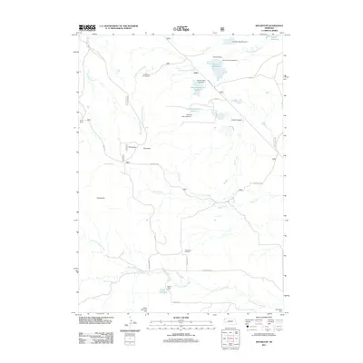
2011 Map of Roundtop
USGS Topo · Published 2011About this map
Union Star Cemetery sits at the southern reach of this Nebraska landscape, serving as a quiet focal point for local genealogy and history. The high plains terrain is defined by a complex network of seasonal drainages, including Big Cottonwood Creek, Sand Creek, and Little Cottonwood Creek, which have necessitated the construction of numerous small-scale water management features like Carbody Dam and Norman Dam Number 1. These earthen structures support several reservoirs, such as Norman Reservoir and Speas Reservoir, indicating the vital importance of water storage for the local ranching economy.
Find a feature on this map
33 named features on this map. Tap any name to fly to it.
Don’t see what you’re looking for? This feature index may not catch every label — zoom into the map to look around manually.
Map Details
Editions of this 2011 Roundtop Map
This is the sole edition of this map. No revisions or reprints were ever made.
Other maps of this area

1955 · Alliance
USGS Topo · 1:250,000

1957 · Alliance
USGS Topo · 1:250,000

1958 · Alliance
USGS Topo · 1:250,000

1980 · Horn
USGS Topo · 1:24,000

1980 · Montrose
USGS Topo · 1:24,000

1980 · Wolf Butte
USGS Topo · 1:24,000

1980 · Smiley Canyon
USGS Topo · 1:24,000

1980 · Five Points
USGS Topo · 1:24,000

1980 · Andrews
USGS Topo · 1:24,000
1980 · Orella
USGS Topo · 1:24,000