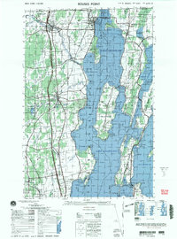
2000 Map of Rouses Point
USGS Topo · Published 2000About this map
The waters of Lake Champlain define this borderland region where New York and Vermont meet the international boundary with Canada. At the northern tip of the lake, the Rouses Point Bridge connects the village of Rouses Point to the Alburg Tongue in Vermont, passing near the historic Fort Montgomery (ruins). This late 20th-century landscape is a complex mix of agricultural land and state-managed conservation areas, such as the Mud Creek State Waterfowl Area and the Lake Alice State Game Management Area.
Find a feature on this map
151 named features on this map. Tap any name to fly to it.
Don’t see what you’re looking for? This feature index may not catch every label — zoom into the map to look around manually.
Map Details
Editions of this 2000 Rouses Point Map
This is the sole edition of this map. No revisions or reprints were ever made.
Other maps of this area

1894 · Plattsburg
USGS Topo · 1:62,500

1895 · Mooers
USGS Topo · 1:62,500

1895 · Rouse Point
USGS Topo · 1:62,500

1899 · Mooers
USGS Topo · 1:62,500

1906 · Plattsburg
USGS Topo · 1:62,500

1907 · Rouse Point
USGS Topo · 1:62,500

1913 · Dannemora
USGS Topo · 1:62,500

1913 · Milton
USGS Topo · 1:48,000

1914 · St. Albans
USGS Topo · 1:48,000

1915 · Milton
USGS Topo · 1:62,500