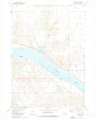
1973 Map of Rousseau
USGS Topo · Published 1976About this map
Lake Sharpe dominates this section of the Missouri River in central South Dakota, marking the boundary between Hughes and Stanley counties. The small settlement of Rousseau sits on the northern bank, served by the Chicago and North Western railroad and the Rousseau Sch. The landscape is defined by deeply eroded draws such as Mosteller Draw and Trumbo Draw that drain into the river valley. To the south, across the water, the Lower Brule Indian Reservation Boundary is clearly delineated alongside the Old Indian Treaty Boundary. Notable landmarks include the Holy Name Chapel and its associated Cem, along with the Roadside Park near the riverbank. This map captures the region's character as a crossroads of indigenous history, early rail infrastructure, and mid-century water management.
Find a feature on this map
29 named features on this map. Tap any name to fly to it.
Don’t see what you’re looking for? This feature index may not catch every label — zoom into the map to look around manually.
Map Details
Editions of this 1973 Rousseau Map
This is the sole edition of this map. No revisions or reprints were ever made.
Other maps of this area

1934 · Canning
USGS Topo · 1:48,000

1937 · Canning
USGS Topo · 1:62,500

1953 · Huron
USGS Topo · 1:250,000

1954 · Pierre
USGS Topo · 1:250,000

1954 · Huron
USGS Topo · 1:250,000

1958 · Pierre
USGS Topo · 1:250,000

1966 · Joe Creek NW
USGS Topo · 1:24,000

1967 · Canning
USGS Topo · 1:24,000
1967 · Canning NW
USGS Topo · 1:24,000

1967 · Ft. George Butte NW
USGS Topo · 1:24,000