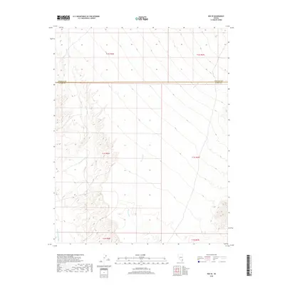
2018 Map of Rox SE
USGS Topo · Published 2018About this map
Meadow Valley Wash defines the southwestern corner of this desert landscape, where the seasonal drainage cuts through the arid basins of the Mojave. This 2018 survey documents a region dominated by intricate alluvial systems, most notably the expansive Whitmore Wash and Weiser Wash, which trend southeast toward the larger drainage networks of southern Nevada. The geography is physically divided by the administrative boundary between Lincoln Co and Clark Co, a line that cuts straight across the varying elevations of the desert floor. Unlike more developed quadrangles, this area remains characterized by its natural drainage patterns and the stark transition between the wash basins and the surrounding upland plateaus.
Find a feature on this map
10 named features on this map. Tap any name to fly to it.
Don’t see what you’re looking for? This feature index may not catch every label — zoom into the map to look around manually.
Map Details
Editions of this 2018 Rox SE Map
This is the sole edition of this map. No revisions or reprints were ever made.
Other maps of this area

1886 · Saint Thomas
USGS Topo · 1:250,000

1893 · Saint Thomas
USGS Topo · 1:250,000

1954 · Las Vegas
USGS Topo · 1:250,000

1957 · Las Vegas
USGS Topo · 1:250,000

1958 · Moapa
USGS Topo · 1:62,500

1958 · Overton
USGS Topo · 1:62,500

1959 · Las Vegas
USGS Topo · 1:250,000

1962 · Las Vegas
USGS Topo · 1:250,000

1969 · Farrier
USGS Topo · 1:24,000
1969 · Rox
USGS Topo · 1:24,000