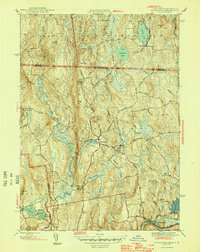
1946 Map of Royalston
USGS Topo · Published 1946About this map
Royalston and its outlying villages sit within a landscape of steep hills and winding river branches in the years immediately following World War II. The topography is defined by the three branches of the Tully River, which descend from the northern New Hampshire border past landmarks like Jacob Hill and Spirit Falls. In the south, the Boston and Maine Railroad follows the path of the Millers River through South Royalston, highlighting the vital rail corridor connecting these valley communities. Scattered throughout the townships of Royalston and Orange are small clusters of development like Fryeville and Packard Heights, while the uplands are dotted with family-named peaks such as Beryl Hill and Tully Mtn. This survey captures the rural character of northern Worcester County before modern highway expansion, preserving the location of local farmsteads such as Neale Place and the intricate network of secondary roads like Butternorth Road.
Find a feature on this map
61 named features on this map. Tap any name to fly to it.
Don’t see what you’re looking for? This feature index may not catch every label — zoom into the map to look around manually.
Map Details
Editions of this 1946 Royalston Map
2 editions found
Other maps of this area

1887 · Warwick
USGS Topo · 1:62,500

1887 · Winchendon
USGS Topo · 1:62,500

1889 · Warwick
USGS Topo · 1:62,500

1890 · Winchendon
USGS Topo · 1:62,500

1894 · Winchendon
USGS Topo · 1:62,500

1894 · Warwick
USGS Topo · 1:62,500

1898 · Monadnock
USGS Topo · 1:62,500

1898 · Keene
USGS Topo · 1:62,500

1932 · Warwick
USGS Topo · 1:48,000

1932 · Winchendon
USGS Topo · 1:48,000