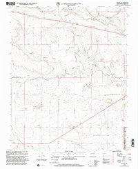
1998 Map of Royce
USGS Topo · Published 2001About this map
Apache Creek and Perico Creek define the drainage patterns of this high plains landscape in northeastern New Mexico, where water management is central to the local cattle-ranching economy. A extensive network of Levees and numerous named water sources, such as McCook Windmill and Ham Windmill, reveal the infrastructure required to sustain livestock across the grassland. The map documents the presence of the Kiowa National Grassland, highlighting the region's character as a managed public landscape.
Find a feature on this map
26 named features on this map. Tap any name to fly to it.
Don’t see what you’re looking for? This feature index may not catch every label — zoom into the map to look around manually.
Map Details
Editions of this 1998 Royce Map
This is the sole edition of this map. No revisions or reprints were ever made.
Other maps of this area

1954 · Dalhart
USGS Topo · 1:250,000

1958 · Dalhart
USGS Topo · 1:250,000

1962 · Dalhart
USGS Topo · 1:250,000

1966 · Royce
USGS Topo · 1:24,000

1966 · Black Canyon
USGS Topo · 1:24,000

1966 · Tate School
USGS Topo · 1:24,000

1966 · Sand Hill
USGS Topo · 1:24,000

1970 · Clayton
USGS Topo · 1:24,000

1970 · Clayton SW
USGS Topo · 1:24,000

1972 · Mount Dora
USGS Topo · 1:24,000