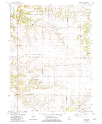
1982 Map of Rozetta
USGS Topo · Published 1983About this map
Rozetta and the surrounding agricultural townships of Bald Bluff and Sumner characterize this Illinois landscape as it appeared in the late 1970s and early 1980s. The map reveals a high density of rural burial grounds, including the Stockton Cem, Coghill Cem, and Rozetta Cem, which are essential for genealogical research in this portion of Henderson County. The terrain is defined by the drainage systems of Henderson Creek and Fall Creek, with the latter hosting the Fall Creek Ch. In the southern reaches, the boundary between Henderson and Warren counties cuts through the area near Youngs Lake and the small settlement of Reeds. The presence of the Carner Landing Strip and Yorkwood Elem Sch reflects the modern infrastructure supporting this traditionally rural community.
Find a feature on this map
28 named features on this map. Tap any name to fly to it.
Don’t see what you’re looking for? This feature index may not catch every label — zoom into the map to look around manually.
Map Details
Editions of this 1982 Rozetta Map
This is the sole edition of this map. No revisions or reprints were ever made.
Other maps of this area

1921 · Monmouth
USGS Topo · 1:62,500

1923 · Monmouth
USGS Topo · 1:62,500

1923 · Alexis
USGS Topo · 1:62,500

1925 · Alexis
USGS Topo · 1:62,500

1934 · Oquawka
USGS Topo · 1:48,000

1935 · Keithsburg
USGS Topo · 1:48,000

1940 · Oquawka
USGS Topo · 1:62,500

1941 · Keithsburg
USGS Topo · 1:62,500

1958 · Burlington
USGS Topo · 1:250,000

1958 · Davenport
USGS Topo · 1:250,000