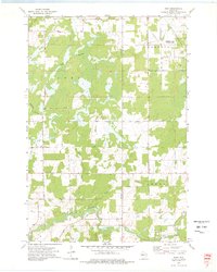
1973 Map of Ruby
USGS Topo · Published 1976About this map
The Ruby Swamps dominate this landscape in north-central Wisconsin, where the border of Chippewa Co and Taylor Co cuts through a dense network of river systems and wildlife management lands. Surveyed in the early 1970s, the map reveals a region defined by its hydrography, with the Fisher River and Yellow River winding through the townships of Ruby, Pershing, and Aurora. Human footprints are sparse but significant, notably the Pershing State Wildlife Area which occupies the northeast corner, providing a glimpse into the conservation efforts of the era.
Find a feature on this map
18 named features on this map. Tap any name to fly to it.
Don’t see what you’re looking for? This feature index may not catch every label — zoom into the map to look around manually.
Map Details
Editions of this 1973 Ruby Map
This is the sole edition of this map. No revisions or reprints were ever made.
Other maps of this area

1947 · Sheldon
USGS Topo · 1:48,000

1948 · Ladysmith
USGS Topo · 1:48,000

1949 · Sheldon
USGS Topo · 1:48,000

1950 · Ladysmith
USGS Topo · 1:48,000

1951 · Cornell
USGS Topo · 1:62,500

1951 · Gilman
USGS Topo · 1:62,500

1953 · Rice Lake
USGS Topo · 1:250,000

1959 · Rice Lake
USGS Topo · 1:250,000
1971 · Jump River
USGS Topo · 1:24,000
1971 · Ladysmith SE
USGS Topo · 1:24,000