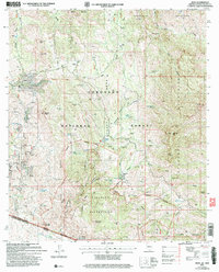
2004 Map of Ruby
USGS Topo · Published 2007About this map
The mining settlement of Ruby sits at the western edge of the Coronado National Forest, serving as a central hub for the mineral-rich mountains of Santa Cruz County. This 2004 survey details a landscape defined by its extractive history, showing numerous prospects and adits clustered near the Montana Mine and Oro Blanco Mine. To the south, the international border with Mexico runs through the Pajarita Wilderness, where the terrain rises toward Flat Top Mountain and Manzanita Mountain. The map illustrates a complex network of water management features necessary for survival and industry in this arid environment, including Pantago Tanks, Salty Tank, and the White Rock Dam. The presence of the California Mine and Dos Amigos Mine further south highlights the intensive exploration that once dominated this section of the Tumacacori Mountains.
Find a feature on this map
90 named features on this map. Tap any name to fly to it.
Don’t see what you’re looking for? This feature index may not catch every label — zoom into the map to look around manually.
Map Details
Editions of this 2004 Ruby Map
This is the sole edition of this map. No revisions or reprints were ever made.
Other maps of this area

1920 · Arivaca
USGS Topo · 1:125,000

1921 · Old Glory
USGS Topo · 1:125,000

1939 · Tubac
USGS Topo · 1:62,500

1941 · Arivaca
USGS Topo · 1:62,500

1942 · Ruby
USGS Topo · 1:62,500

1942 · Oro Blanco
USGS Topo · 1:62,500

1943 · Arivaca
USGS Topo · 1:62,500

1943 · Old Glory
USGS Topo · 1:125,000

1943 · Tubac
USGS Topo · 1:62,500

1944 · Oro Blanco
USGS Topo · 1:62,500