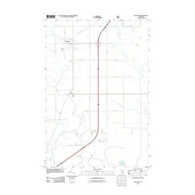
2011 Map of Rudyard
USGS Topo · Published 2011About this map
Rudyard sits as a primary junction in the Upper Peninsula, where a regular grid of section roads meets the modern interstate corridor. This landscape is defined by its water systems, primarily the Munuscong River to the east and the branching network of the North Pine River and Pine River to the west. These waterways, along with Chub Creek and Hiawatha Run, carve through a terrain of low relief typical of Chippewa County. For genealogists and local historians, the proximity of the South Rudyard Cemetery and Saint Rudyard Cemetery near the smaller settlement of South Rudyard provides a clear focal point for tracing early family plots. The concentration of civic life is found around the Rudyard Post Office, while the surrounding rural blocks are named for local families such as S Tilson Rd, S Peffers Rd, and S Hantz Rd, reflecting a legacy of settlement and land ownership along these mile-grid routes.
Find a feature on this map
36 named features on this map. Tap any name to fly to it.
Don’t see what you’re looking for? This feature index may not catch every label — zoom into the map to look around manually.
Map Details
Editions of this 2011 Rudyard Map
This is the sole edition of this map. No revisions or reprints were ever made.
Other maps of this area

1913 · Sault Sainte Marie
USGS Topo · 1:62,500

1941 · Sault Sainte Marie
USGS Topo · 1:63,360

1941 · Brimley
USGS Topo · 1:63,360

1951 · Raco
USGS Topo · 1:24,000

1951 · Kinross
USGS Topo · 1:24,000

1951 · Dafter
USGS Topo · 1:24,000

1951 · Brimley
USGS Topo · 1:62,500

1951 · Sault Ste. Marie
USGS Topo · 1:62,500

1953 · Pickford NW
USGS Topo · 1:24,000
1953 · Rudyard
USGS Topo · 1:24,000