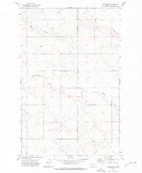
1972 Map of Rudyard NE
USGS Topo · Published 1975About this map
Big Coulee and O'Brien Coulee carve through this high plains landscape of Hill County, where the terrain is marked by the infrastructure of industrial dryland farming. The map depicts a functional agricultural grid just after the turn of the 1970s, characterized by numerous Storage Bins clustered near section lines and isolated Gas Well sites that reflect the region's energy resources. The transportation network is defined by the primary Rudyard Road and several remote Landing Strips, which allowed for aerial crop dusting and quick access across these expansive Montana sections. This survey provides a precise look at the land use and drainage patterns of the northern plains before modern consolidation changed the footprint of local farmsteads.
Find a feature on this map
6 named features on this map. Tap any name to fly to it.
Don’t see what you’re looking for? This feature index may not catch every label — zoom into the map to look around manually.
Map Details
Editions of this 1972 Rudyard NE Map
This is the sole edition of this map. No revisions or reprints were ever made.
Other maps of this area

1919 · Alma
USGS Topo · 1:125,000

1920 · Gildford
USGS Topo · 1:125,000

1943 · Gildford
USGS Topo · 1:125,000

1954 · Shelby
USGS Topo · 1:250,000

1958 · Shelby
USGS Topo · 1:250,000

1969 · Gildford NW
USGS Topo · 1:24,000

1969 · Hingham
USGS Topo · 1:24,000
1972 · Rudyard
USGS Topo · 1:24,000

1972 · Goldstone SW
USGS Topo · 1:24,000

1972 · Rudyard NW
USGS Topo · 1:24,000