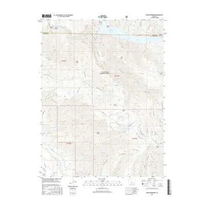
2016 Map of Ruedi Reservoir
USGS Topo · Published 2016About this map
Ruedi Reservoir dominates the northern landscape of this Pitkin and Eagle County border region, where the Fryingpan River is impounded amidst the high peaks of the White River National Forest. The map documents a complex network of high-altitude drainages and ridges, including Vagneur Mtn and Larkspur Mtn, separated by deep cuts like Red Canyon. This 2016 survey captures the area's transition from a historic mining and logging landscape to a modern recreational hub, evidenced by the numerous named paths such as the Arbaneykittle Trail and Hannon Creek Trail. The settlement of Lenado sits in the southern portion along Woody Creek, serving as a focal point for researchers interested in the legacy of late 19th-century resource extraction. Notable localized place names like Saloon Gulch and Stockyard Gulch hint at the area's early frontier activity and livestock history.
Find a feature on this map
54 named features on this map. Tap any name to fly to it.
Don’t see what you’re looking for? This feature index may not catch every label — zoom into the map to look around manually.
Map Details
Editions of this 2016 Ruedi Reservoir Map
This is the sole edition of this map. No revisions or reprints were ever made.
Other maps of this area

1893 · Aspen
USGS Topo · 1:62,500

1895 · Aspen
USGS Topo · 1:62,500

1909 · Mount Jackson
USGS Topo · 1:125,000

1911 · Mount Jackson
USGS Topo · 1:125,000

1957 · Leadville
USGS Topo · 1:250,000

1959 · Leadville
USGS Topo · 1:250,000

1960 · Leadville
USGS Topo · 1:250,000

1960 · Highland Peak
USGS Topo · 1:24,000
1960 · Thimble Rock
USGS Topo · 1:24,000

1960 · Aspen
USGS Topo · 1:24,000