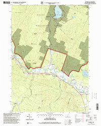
1995 Map of Rumney
USGS Topo · Published 2000About this map
The Baker River corridor defines the geography of this mid-1990s survey, following a winding valley that connects a string of rural settlements from West Rumney through Rumney Depot to West Plymouth. The landscape is dominated by the southern reaches of the White Mountain National Forest, where steep terrain rises toward Carr Mountain and Stinson Mountain. Around the village of Rumney, evidence of the local economy and infrastructure appears in the form of multiple Gravel Pits, a Quarry near Fletcher Mountain, and the Russell Sch. To the north, Stinson Lake serves as a significant focal point, complete with a Boat Ramp, while the southeastern corner of the quadrangle shows the development of the Plymouth Municipal Airport. The map also captures several recreation paths, including the Rattlesnake Mountain Trail and Stinson Mountain Trail, tracing the area's transition from an industrial and agricultural hub into a protected forest landscape.
Find a feature on this map
41 named features on this map. Tap any name to fly to it.
Don’t see what you’re looking for? This feature index may not catch every label — zoom into the map to look around manually.
Map Details
Editions of this 1995 Rumney Map
This is the sole edition of this map. No revisions or reprints were ever made.
Other maps of this area

1925 · Holderness
USGS Topo · 1:62,500

1927 · Holderness
USGS Topo · 1:62,500

1927 · Cardigan
USGS Topo · 1:62,500

1928 · Plymouth
USGS Topo · 1:62,500

1928 · Rumney
USGS Topo · 1:62,500

1930 · Cardigan
USGS Topo · 1:62,500

1931 · Plymouth
USGS Topo · 1:62,500

1932 · Rumney
USGS Topo · 1:62,500

1949 · Portland
USGS Topo · 1:250,000

1956 · Cardigan
USGS Topo · 1:62,500