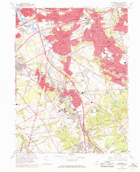
1967 Map of Runnemede
USGS Topo · Published 1969About this map
Big Timber Creek and its many branches, including the South Branch and North Branch, carve through this section of southern New Jersey during a period of intense suburbanization. The landscape is a dense network of residential boroughs like Runnemede, Glendora, and Magnolia, interspersed with critical regional infrastructure. This late 1960s perspective shows the convergence of the New Jersey Turnpike and the Atlantic City Expressway, signaling the area's role as a transportation hub for the Philadelphia metro region. Education and public health centers are prominent, featuring Camden County College and the Lakeland General Hospital complex, which includes the county jail. While residential red-tinted zones dominate, the map still records the industrial footprint of numerous gravel pits and the legacy of the Pennsylvania Reading Seashore Lines moving through Stratford and Lindenwold.
Find a feature on this map
115 named features on this map. Tap any name to fly to it.
Don’t see what you’re looking for? This feature index may not catch every label — zoom into the map to look around manually.
Map Details
Editions of this 1967 Runnemede Map
4 editions found
Other maps of this area

1888 · Mount Holly
USGS Topo · 1:62,500

1890 · Hammonton
USGS Topo · 1:62,500

1890 · Glassboro
USGS Topo · 1:62,500

1891 · Philadelphia
USGS Topo · 1:62,500

1894 · Hammonton
USGS Topo · 1:62,500

1894 · Mount Holly
USGS Topo · 1:62,500

1894 · Philadelphia
USGS Topo · 1:62,500

1896 · Philadelphia
USGS Topo · 1:62,500

1898 · Glassboro
USGS Topo · 1:62,500

1898 · Philadelphia
USGS Topo · 1:62,500
Featured Places
- Cherry Hill Township, NJ
- Washington Township, NJ
- Deptford Township, NJ
- Voorhees Township, NJ
- Lindenwold, NJ