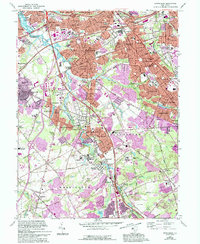
1967 Map of Runnemede
USGS Topo · Published 1994About this map
The suburban development of southern New Jersey is captured here as communities like Runnemede and Bellmawr expanded alongside major transportation corridors. The North-South Freeway and New Jersey Turnpike intersect in the north, fundamentally altering the landscape around the Pennsylvania-Reading Seashore Lines. Despite this modernization, older settlement patterns remain visible in places like Good Intent and Clements Bridge, while the South Branch Big Timber Creek continues to define the natural boundary between Camden and Gloucester counties.
Find a feature on this map
116 named features on this map. Tap any name to fly to it.
Don’t see what you’re looking for? This feature index may not catch every label — zoom into the map to look around manually.
Map Details
Editions of this 1967 Runnemede Map
4 editions found
Other maps of this area

1888 · Mount Holly
USGS Topo · 1:62,500

1890 · Hammonton
USGS Topo · 1:62,500

1890 · Glassboro
USGS Topo · 1:62,500

1891 · Philadelphia
USGS Topo · 1:62,500

1894 · Hammonton
USGS Topo · 1:62,500

1894 · Mount Holly
USGS Topo · 1:62,500

1894 · Philadelphia
USGS Topo · 1:62,500

1896 · Philadelphia
USGS Topo · 1:62,500

1898 · Glassboro
USGS Topo · 1:62,500

1898 · Philadelphia
USGS Topo · 1:62,500
Featured Places
- Cherry Hill Township, NJ
- Washington Township, NJ
- Deptford Township, NJ
- Voorhees Township, NJ
- Lindenwold, NJ