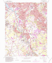
1967 Map of Runnemede
USGS Topo · Published 1984About this map
Big Timber Creek and its south branch serve as the primary drainage and historical boundary between Camden and Gloucester counties, anchoring a landscape defined by rapid suburban expansion. During this mid-century period, the area around Runnemede and Blackwood shows the maturing infrastructure of the Philadelphia suburbs, where older crossings like Clements Bridge met the modern throughput of the New Jersey Turnpike.
Find a feature on this map
121 named features on this map. Tap any name to fly to it.
Don’t see what you’re looking for? This feature index may not catch every label — zoom into the map to look around manually.
Map Details
Editions of this 1967 Runnemede Map
4 editions found
Other maps of this area

1888 · Mount Holly
USGS Topo · 1:62,500

1890 · Hammonton
USGS Topo · 1:62,500

1890 · Glassboro
USGS Topo · 1:62,500

1891 · Philadelphia
USGS Topo · 1:62,500

1894 · Hammonton
USGS Topo · 1:62,500

1894 · Mount Holly
USGS Topo · 1:62,500

1894 · Philadelphia
USGS Topo · 1:62,500

1896 · Philadelphia
USGS Topo · 1:62,500

1898 · Glassboro
USGS Topo · 1:62,500

1898 · Philadelphia
USGS Topo · 1:62,500
Featured Places
- Cherry Hill Township, NJ
- Washington Township, NJ
- Deptford Township, NJ
- Voorhees Township, NJ
- Lindenwold, NJ