
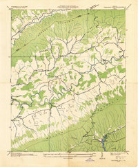
1931 Map of Rural Retreat
USGS Topo · Published 1931About this map
The Middle Fork Holston River and South Fork Holston River carve through this landscape within the Unaka National Forest, defining the settlement patterns of the early 1930s. The northern corridor follows the Norfolk and Western railroad and the Lee Highway, connecting Atkins and Rural Retreat. In the more isolated southern valleys, smaller communities like Sugar Grove and Fisher rely on local landmarks such as Roberts Mill and the Old Iron Mine. The map reveals a dense network of rural infrastructure, including numerous one-room schoolhouses like Lindywood Sch and Summit Sch, alongside central gathering points such as Groseclose Chapel and St Matthews Ch. This survey provides a look at the region before modern highway expansions, showing the proximity of family sites like Wasson Cem to the primary transit routes of the era.
Find a feature on this map
46 named features on this map. Tap any name to fly to it.
Don’t see what you’re looking for? This feature index may not catch every label — zoom into the map to look around manually.
Map Details
Editions of this 1931 Rural Retreat Map
This is the sole edition of this map. No revisions or reprints were ever made.
Other maps of this area

1889 · Wytheville
USGS Topo · 1:125,000

1891 · Abingdon
USGS Topo · 1:125,000

1892 · Wytheville
USGS Topo · 1:125,000

1894 · Abingdon
USGS Topo · 1:125,000

1909 · Abingdon
USGS Topo · 1:96,000

1911 · Abingdon
USGS Topo · 1:125,000

1930 · Speedwell
USGS Topo · 1:62,500

1930 · Independence
USGS Topo · 1:48,000

1933 · Independence
USGS Topo · 1:62,500
1934 · Chatham Hill
USGS Topo · 1:24,000