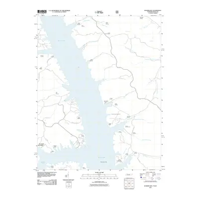
2011 Map of Rushing Bay
USGS Topo · Published 2011About this map
Kentucky Lake dominates this landscape, where the inundated valleys of the Tennessee River basin create a complex shoreline of deep inlets and points. Along the western shore, the settlement of Boatwright sits near the head of Hooper Hollow, surrounded by numerous family burial grounds like McDaniel Cemetery and Lone Oak Cemetery that testify to the long-standing community roots in Calloway County. The eastern shore is characterized by recreational and conservation spaces, including the Rushing Creek Campground and the Jones Creek Day Use Area.
Find a feature on this map
56 named features on this map. Tap any name to fly to it.
Don’t see what you’re looking for? This feature index may not catch every label — zoom into the map to look around manually.
Map Details
Editions of this 2011 Rushing Bay Map
This is the sole edition of this map. No revisions or reprints were ever made.
Other maps of this area

1936 · Tharpe
USGS Topo · 1:24,000

1936 · New Concord
USGS Topo · 1:24,000

1936 · Hamlin
USGS Topo · 1:24,000

1936 · Fenton
USGS Topo · 1:24,000

1936 · Hiatt
USGS Topo · 1:24,000

1936 · Golden Pond
USGS Topo · 1:48,000

1936 · Rushing
USGS Topo · 1:24,000

1936 · Hico
USGS Topo · 1:24,000
1940 · Hiatt
USGS Topo · 1:24,000

1942 · New Concord
USGS Topo · 1:24,000