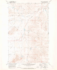
1970 Map of Russell Chapel
USGS Topo · Published 1973About this map
Russell Chapel stands as a focal point in this portion of Chouteau County, where the high plains transition into the drainage of Dugout Coulee. The landscape is defined by its agricultural utility, marked by family holdings like the Bar Z F Ranch and Stewart Ranch, and the expansive terrain of Sample Flat. This 1970s survey, conducted for the development of the Missouri River Basin, reveals a sparsely settled but organized ranching environment. Transportation and logistics of the era are visible through the inclusion of a Landing Strip near the northern coulee and a local Gravel Pit. Genealogists may find particular value in the location of the Sample Flat Cem, a remote burial site that anchors the history of the surrounding plateau. The map's detail on ephemeral water sources, such as various unnamed springs and the North Fork Dugout Coulee, illustrates the critical importance of water management in this arid Montana country.
Find a feature on this map
13 named features on this map. Tap any name to fly to it.
Don’t see what you’re looking for? This feature index may not catch every label — zoom into the map to look around manually.
Map Details
Editions of this 1970 Russell Chapel Map
This is the sole edition of this map. No revisions or reprints were ever made.
Other maps of this area

1886 · Great Falls
USGS Topo · 1:250,000

1890 · Fort Benton
USGS Topo · 1:250,000

1892 · Fort Benton
USGS Topo · 1:250,000

1897 · Fort Benton
USGS Topo · 1:250,000

1950 · Dent Bridge
USGS Topo · 1:62,500

1954 · Great Falls
USGS Topo · 1:250,000

1954 · Shelby
USGS Topo · 1:250,000

1957 · Great Falls
USGS Topo · 1:250,000

1958 · Shelby
USGS Topo · 1:250,000

1970 · Carlson Coulee
USGS Topo · 1:24,000