
1984 Map of Russellville
USGS Topo · Published 1984About this map
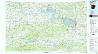
The Arkansas River corridor serves as the primary artery for this mid-1980s landscape, where industrial activity and educational centers meet the southern edges of the Ozark National Forest. Higher education is well-represented by Arkansas Tech Univ in Russellville and the College of the Ozarks in Clarksville, while the river itself is transformed by the expanse of Lake Dardanelle. The regional economy of the period is marked by the presence of a Strip Mine and Gravel Pit workings, alongside the transit corridors of the Missouri Pacific RR and the Chicago Rock Island & Pacific RR.
Find a feature on this map
203 named features on this map. Tap any name to fly to it.
Don’t see what you’re looking for? This feature index may not catch every label — zoom into the map to look around manually.
Map Details
Editions of this 1984 Russellville Map
2 editions found
Other maps of this area

1879 · Poteau Mountain
USGS Topo · 1:62,500

1879 · Cravens
USGS Topo · 1:62,500

1879 · Mountain Home
USGS Topo · 1:62,500

1879 · Washington
USGS Topo · 1:62,500

1887 · Poteau Mountain #1
USGS Topo · 1:62,500

1887 · Magazine Mountain #1
USGS Topo · 1:62,500

1887 · Smyrna
USGS Topo · 1:62,500

1887 · Magazine Mountain #4
USGS Topo · 1:62,500

1887 · Mount Ida #2
USGS Topo · 1:62,500

1887 · Magazine Mountain #2
USGS Topo · 1:62,500