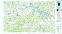
1984 Map of Russellville
USGS Topo · Published 1984About this map
Lake Dardanelle dominates the central river valley on this mid-1980s survey, illustrating the managed waters of the Arkansas River following major infrastructure projects like the Dardanelle Lock & Dam. The map covers a complex geographic interface between the Ozark National Forest to the north and the Ouachita National Forest to the south. This era shows Russellville and Clarksville as established regional hubs connected by Interstate 40, while smaller settlements such as Subiaco and Paris retain their distinct character in the shadow of Magazine Mountain.
Find a feature on this map
318 named features on this map. Tap any name to fly to it.
Don’t see what you’re looking for? This feature index may not catch every label — zoom into the map to look around manually.
Map Details
Editions of this 1984 Russellville Map
2 editions found
Other maps of this area

1879 · Poteau Mountain
USGS Topo · 1:62,500

1879 · Cravens
USGS Topo · 1:62,500

1879 · Mountain Home
USGS Topo · 1:62,500

1879 · Washington
USGS Topo · 1:62,500

1887 · Poteau Mountain #1
USGS Topo · 1:62,500

1887 · Magazine Mountain #1
USGS Topo · 1:62,500

1887 · Smyrna
USGS Topo · 1:62,500

1887 · Magazine Mountain #4
USGS Topo · 1:62,500

1887 · Mount Ida #2
USGS Topo · 1:62,500

1887 · Magazine Mountain #2
USGS Topo · 1:62,500