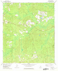
1982 Map of Rutan
USGS Topo · Published 1982About this map
Chatom serves as a prominent focal point in this 1980s landscape, characterized by its concentration of civic and community infrastructure including the County Hospital, an Armory, and the Chatom Municipal Airport. The settlement pattern follows the high ground between extensive drainage networks, such as Little Bassetts Creek and Johnson Creek, which feed into the broad wetlands of Calf Pasture Swamp and Bull Hall Swamp to the northeast. To the east, the communities of Hobson and Rutan appear alongside local landmarks like Lake Marie and Pine Level Ch. The southern portion of the map transitions into more remote terrain, where the Turner Lookout Tower stands near Armstrong Creek, overlooking a network of smaller drainages like Whiteoak Branch and Beaverdam Creek. This period captures the area as it balanced its role as a county service center with the surrounding timber and wetland environments.
Find a feature on this map
34 named features on this map. Tap any name to fly to it.
Don’t see what you’re looking for? This feature index may not catch every label — zoom into the map to look around manually.
Map Details
Editions of this 1982 Rutan Map
This is the sole edition of this map. No revisions or reprints were ever made.
Other maps of this area

1943 · McIntosh
USGS Topo · 1:62,500

1944 · McIntosh
USGS Topo · 1:62,500

1953 · Hattiesburg
USGS Topo · 1:250,000

1958 · Hattiesburg
USGS Topo · 1:250,000

1971 · Bigbee
USGS Topo · 1:24,000

1972 · St. Stephens
USGS Topo · 1:24,000

1974 · Millry South
USGS Topo · 1:24,000

1974 · Chatom
USGS Topo · 1:24,000

1974 · Vinegar Bend
USGS Topo · 1:24,000
1982 · Wagarville
USGS Topo · 1:24,000