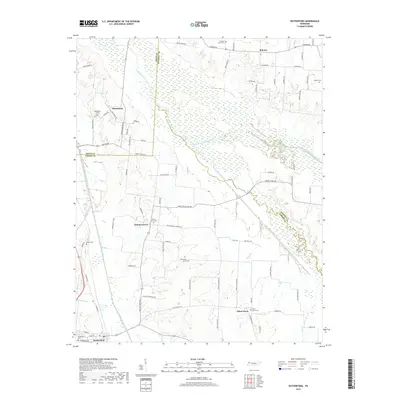
2019 Map of Rutherford
USGS Topo · Published 2019About this map
The Rutherford Fork Obion River and its sister branches, the Middle Fork Obion River and South Fork Obion River, dominate the hydrology of this West Tennessee landscape where the borders of Gibson, Obion, and Weakley counties converge. In the town of Rutherford, the local cemetery and street grid sit near the banks of the Rutherford Fork Obion River, reflecting a settlement pattern deeply tied to the regional river system. The surrounding countryside is defined by small, long-standing communities such as Walnut Grove, China Grove, and Sidonia, each anchored by historical burial grounds like the Walnut Grove Cem and China Grove Cem.
Find a feature on this map
84 named features on this map. Tap any name to fly to it.
Don’t see what you’re looking for? This feature index may not catch every label — zoom into the map to look around manually.
Map Details
Editions of this 2019 Rutherford Map
This is the sole edition of this map. No revisions or reprints were ever made.
Other maps of this area

1950 · Martin
USGS Topo · 1:24,000

1950 · Rives
USGS Topo · 1:24,000

1951 · Rives
USGS Topo · 1:24,000

1953 · Dyer
USGS Topo · 1:24,000

1954 · Rutherford
USGS Topo · 1:24,000

1954 · Greenfield
USGS Topo · 1:24,000

1954 · Bradford
USGS Topo · 1:24,000

1956 · Gardner
USGS Topo · 1:24,000

1956 · Dyersburg
USGS Topo · 1:250,000
1964 · Yorkville
USGS Topo · 1:24,000