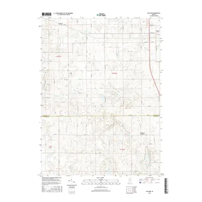
2016 Map of Rutland
USGS Topo · Published 2016About this map
Argos sits at the northeastern corner of this Marshall County landscape, where the grain-growing plains of northern Indiana are defined by an intricate network of drainage systems. The transition from Marshall Co into Fulton Co to the south reveals a terrain of glacially formed depressions and watercourses like Clifton Ditch and Wolf Cr. Small settlements such as Richland Center and Rutland anchor a grid of rural roads named for trees and nuts, including Nutmeg Rd and Peach Rd. This 2016 survey illustrates the persistent agricultural character of the region, where numerous named ditches like the B F Overmyer Ditch and Miller Ditch manage the water table around scattered kettle lakes. Pockets of standing water, including O'Blennis Lake, Zink Lake, and Mud Lake, remain as significant landmarks amidst the structured farm plots and local air strips like DDT Field.
Find a feature on this map
84 named features on this map. Tap any name to fly to it.
Don’t see what you’re looking for? This feature index may not catch every label — zoom into the map to look around manually.
Map Details
Editions of this 2016 Rutland Map
This is the sole edition of this map. No revisions or reprints were ever made.
Other maps of this area

1953 · Chicago
USGS Topo · 1:250,000

1957 · Chicago
USGS Topo · 1:250,000

1957 · Inwood
USGS Topo · 1:24,000

1957 · Plymouth
USGS Topo · 1:24,000

1958 · Donaldson
USGS Topo · 1:24,000

1962 · Pershing
USGS Topo · 1:24,000

1962 · Kewanna
USGS Topo · 1:24,000

1962 · Argos
USGS Topo · 1:24,000
1962 · Rochester
USGS Topo · 1:24,000

1962 · Culver
USGS Topo · 1:24,000