
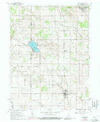
1962 Map of Kewanna
USGS Topo · Published 1964About this map
The Indian Treaty Boundary cuts across the northern landscape of this rural Indiana quadrangle, a significant historical marker in the development of Fulton and Pulaski counties. The Tippecanoe River winds through the northeast corner near Leiters Ford, while the community of Kewanna anchors the south. The area is defined by a dense network of agricultural drainage infrastructure, including the Lunsford Ditch, Guise Ditch, and Overmyer Ditch, which converted the natural wetlands into productive farmland.
Find a feature on this map
50 named features on this map. Tap any name to fly to it.
Don’t see what you’re looking for? This feature index may not catch every label — zoom into the map to look around manually.
Map Details
Editions of this 1962 Kewanna Map
2 editions found
Other maps of this area

1953 · Chicago
USGS Topo · 1:250,000

1953 · Danville
USGS Topo · 1:250,000

1955 · Danville
USGS Topo · 1:250,000

1956 · Danville
USGS Topo · 1:250,000

1957 · Chicago
USGS Topo · 1:250,000

1960 · Fulton
USGS Topo · 1:24,000

1960 · Grass Creek
USGS Topo · 1:24,000

1962 · Pershing
USGS Topo · 1:24,000

1962 · Winamac
USGS Topo · 1:24,000

1962 · Star City
USGS Topo · 1:24,000