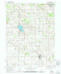
1962 Map of Kewanna
USGS Topo · Published 1989About this map
The Tippecanoe River winds through the northeast corner of this Fulton County landscape, where the Old Indian Treaty Bdy cuts a historical diagonal across the township lines. The village of Kewanna serves as a local hub in the south, featuring the Township Sch, an Athletic Field, and the IOOF Cem. Further north, the recreation and transit corridor around Bruce Lake is well-defined, showing the proximity of Bruce Lake Station and the Chesapeake and Ohio rail line. This 1962 survey reveals a complex network of agricultural drainage, with dozens of named channels like Lunsford Ditch and Wolf Ditch reclaiming the prairie for farming. Genealogists will find several burial grounds, including the Moon Cem and Barnett Cem, alongside rural landmarks such as Sharon Ch and Pleasant Hill Ch.
Find a feature on this map
44 named features on this map. Tap any name to fly to it.
Don’t see what you’re looking for? This feature index may not catch every label — zoom into the map to look around manually.
Map Details
Editions of this 1962 Kewanna Map
2 editions found

Other maps of this area

1953 · Chicago
USGS Topo · 1:250,000

1953 · Danville
USGS Topo · 1:250,000

1955 · Danville
USGS Topo · 1:250,000

1956 · Danville
USGS Topo · 1:250,000

1957 · Chicago
USGS Topo · 1:250,000

1960 · Fulton
USGS Topo · 1:24,000

1960 · Grass Creek
USGS Topo · 1:24,000

1962 · Pershing
USGS Topo · 1:24,000

1962 · Winamac
USGS Topo · 1:24,000

1962 · Star City
USGS Topo · 1:24,000