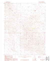
1987 Map of Ryan Canyon
USGS Topo · Published 1987About this map
Agai Pah Hills and the Gillis Range dominate this high-desert landscape in Mineral County, Nevada. As of the mid-1980s, the area reflects a significant history of mineral exploration, evidenced by a high density of mining-related features. The Buckley Mine is a focal point of activity near Buckley Flat, accompanied by specialized features such as the Prospects Adit and various unnamed adits. The terrain is characterized by steep elevation changes, with Ryan Canyon cutting through the southeastern portion of the sheet. Utility infrastructure is present in the form of a Trans Line crossing the southwestern corner, indicating the connectivity of this mining district to larger regional networks. This provisional survey provides a precise look at the industrial footprint of small-scale mining operations and geologic prospecting before modern site reclamations altered the surface.
Find a feature on this map
10 named features on this map. Tap any name to fly to it.
Don’t see what you’re looking for? This feature index may not catch every label — zoom into the map to look around manually.
Map Details
Editions of this 1987 Ryan Canyon Map
This is the sole edition of this map. No revisions or reprints were ever made.
Other maps of this area

1909 · Hawthorne
USGS Topo · 1:250,000

1911 · Hawthorne
USGS Topo · 1:250,000

1915 · Hawthorne
USGS Topo · 1:250,000

1948 · Walker Lake
USGS Topo · 1:250,000

1955 · Hawthorne
USGS Topo · 1:62,500

1957 · Walker Lake
USGS Topo · 1:250,000

1962 · Walker Lake
USGS Topo · 1:250,000

1964 · Walker Lake
USGS Topo · 1:250,000

1964 · Gillis Canyon
USGS Topo · 1:62,500
1979 · Copper Mtn.
USGS Topo · 1:24,000