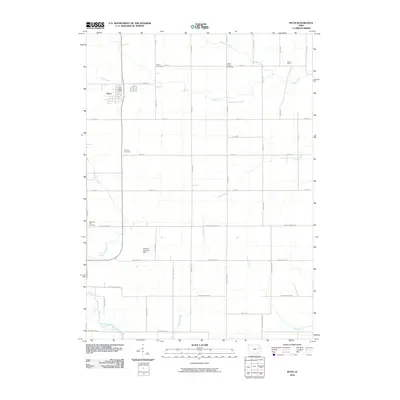
2010 Map of Ryan
USGS Topo · Published 2010About this map
The town of Ryan serves as the primary hub of this eastern Iowa landscape, characterized by a dense grid of rural roads and fertile agricultural land. Evidence of long-standing community roots is found at several burial grounds, including Peace Cemetery, Golden Prairie Cemetery, and Calvary Cemetery, which likely hold significant value for local genealogists. The settlement of Hazel Green occupies the northeastern corner of the sheet, while the presence of the LeClere Landing Strip near the center of the quadrangle highlights the intersection of modern utility with the traditional farmstead layout.
Find a feature on this map
44 named features on this map. Tap any name to fly to it.
Don’t see what you’re looking for? This feature index may not catch every label — zoom into the map to look around manually.
Map Details
Editions of this 2010 Ryan Map
This is the sole edition of this map. No revisions or reprints were ever made.
Other maps of this area

1888 · Marion
USGS Topo · 1:62,500

1889 · Marion
USGS Topo · 1:62,500

1890 · Anamosa
USGS Topo · 1:62,500

1900 · Anamosa
USGS Topo · 1:125,000

1903 · Winthrop
USGS Topo · 1:125,000

1959 · Dubuque
USGS Topo · 1:250,000

1961 · Dubuque
USGS Topo · 1:250,000

1962 · Dubuque
USGS Topo · 1:250,000
1968 · Central City
USGS Topo · 1:24,000
1973 · Manchester
USGS Topo · 1:24,000