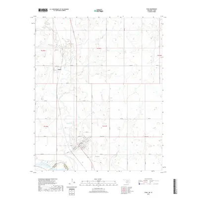
2019 Map of Ryan
USGS Topo · Published 2019About this map
The Red River forms a significant natural boundary at the southern edge of this landscape, separating Oklahoma and Texas. This area is defined by the convergence of several major drainages, most notably Beaver Creek and its many tributaries like Squirrel Cr and Hackberry Cr, which carve a winding path through the terrain. The town of Ryan serves as the primary hub, showing a traditional grid of streets including Main St, Washington St, and Lee St. Further north, the smaller settlement of Sugden is situated along the corridor of NS 10 and Choctaw Ave. Genealogists will find the locations of Ryan Cem and Sugden Cem useful for documenting local family histories near these two established rural communities.
Find a feature on this map
53 named features on this map. Tap any name to fly to it.
Don’t see what you’re looking for? This feature index may not catch every label — zoom into the map to look around manually.
Map Details
Editions of this 2019 Ryan Map
This is the sole edition of this map. No revisions or reprints were ever made.
Other maps of this area

1901 · Addington
USGS Topo · 1:125,000

1905 · Montague
USGS Topo · 1:125,000

1954 · Sherman
USGS Topo · 1:250,000

1954 · Wichita Falls
USGS Topo · 1:250,000

1955 · Lawton
USGS Topo · 1:250,000

1956 · Henrietta
USGS Topo · 1:62,500

1957 · Hastings
USGS Topo · 1:62,500

1957 · Ardmore
USGS Topo · 1:250,000

1958 · Wichita Falls
USGS Topo · 1:250,000

1958 · Sherman
USGS Topo · 1:250,000