
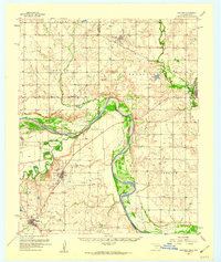
1957 Map of Hastings
USGS Topo · Published 1957About this map
The Red River defines the border between Oklahoma and Texas in this 1957 survey, where the river's meandering course carves through a landscape of creek valleys and petroleum development. The town of Hastings sits near the northern edge, served by the Chicago Rock Island and Pacific railroad, which runs southeast toward Waurika. To the south in Clay County, Texas, the Petrolia Oil Field and the community of Petrolia reflect the region's industrial footprint, supported by numerous oil wells and a nearby pumping station on Pumpkin Ridge.
Find a feature on this map
32 named features on this map. Tap any name to fly to it.
Don’t see what you’re looking for? This feature index may not catch every label — zoom into the map to look around manually.
Map Details
Editions of this 1957 Hastings Map
2 editions found
Other maps of this area

1901 · Addington
USGS Topo · 1:125,000

1905 · Montague
USGS Topo · 1:125,000

1954 · Sherman
USGS Topo · 1:250,000

1954 · Wichita Falls
USGS Topo · 1:250,000

1955 · Lawton
USGS Topo · 1:250,000

1956 · Henrietta
USGS Topo · 1:62,500

1957 · Randlett
USGS Topo · 1:62,500

1957 · Wichita Falls East
USGS Topo · 1:62,500

1957 · Ardmore
USGS Topo · 1:250,000

1958 · Wichita Falls
USGS Topo · 1:250,000