
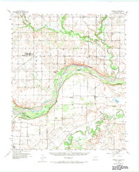
1957 Map of Randlett
USGS Topo · Published 1958About this map
Randlett and its surrounding ranchlands straddle the border of Oklahoma and Texas during the mid-century petroleum boom. This survey documents a landscape defined by its river systems and mineral wealth, specifically the Wichita River and the meandering Cache Creek. The development of the regional oil economy is evident in the sprawling Cache Creek Oil Field and the Thornberry Oil Field, which share the terrain with established agricultural settlements like Thornberry and Charlie.
Find a feature on this map
35 named features on this map. Tap any name to fly to it.
Don’t see what you’re looking for? This feature index may not catch every label — zoom into the map to look around manually.
Map Details
Editions of this 1957 Randlett Map
2 editions found
Other maps of this area

1915 · Burkburnett
USGS Topo · 1:24,000

1918 · Buckburnett
USGS Topo · 1:31,680

1954 · Wichita Falls
USGS Topo · 1:250,000

1955 · Lawton
USGS Topo · 1:250,000

1956 · Henrietta
USGS Topo · 1:62,500

1957 · Hastings
USGS Topo · 1:62,500

1957 · Wichita Falls West
USGS Topo · 1:24,000

1957 · Burkburnett
USGS Topo · 1:62,500

1957 · Wichita Falls East
USGS Topo · 1:62,500

1957 · Wichita Falls East
USGS Topo · 1:24,000