Old Maps of Cotton County, Oklahoma
Explore 122 old maps of Cotton County, spanning from 1915 to today. These high-resolution historic maps reveal how streets, neighborhoods, landmarks, and natural features evolved over time — perfect for genealogy, metal detecting, research, and local history exploration.
What you can do with these maps:
- See how Cotton County changed over time: Compare historical maps to modern-day views to trace roads, homesites, rail lines & more.
- View detailed metadata: Each map includes creators, publishers, year, scale, and archive source.
- Overlay maps with satellite & LiDAR: Visualize the past alongside modern tools to explore terrain & human change.
- Trusted historical sources: Maps sourced from the USGS, Library of Congress, and other archives.
- Access maps your way: View online, download high-res files, or order prints for personal or research use.
Start exploring old maps of Cotton County to uncover forgotten places, hidden landmarks, and the deep history beneath your feet.
Cotton County, OK maps
(122)- 1915 Map of Burkburnett, 1961 Print
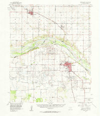
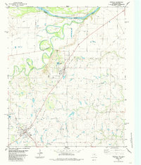
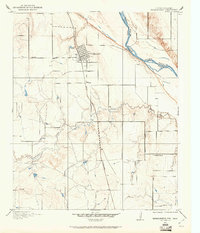 1915 Burkburnett1961 Print · USGSThe Texas-Oklahoma borderlands south of the Red River are shown here in the mid-1910s as rail and road networks began to reshape the frontier. Researchers can trace the early layout of Burkburnett, the location of the Cashion School, and the route of the Wichita Falls and Northwestern railroad.
 - 1918 Map of Buckburnett
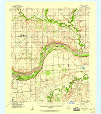
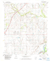
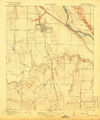 1918 Buckburnett1918 Print · USGSWichita County sits on the edge of a historic oil boom during the late nineteen-teens, dominated by the winding Red River border. Genealogists and historians can trace early town plats in Burkburnett, rural landmarks like Cashion School, and the path of the Wichita Falls and Northwestern railroad.3 unique versions available
 - 1949 Map of Nellie, 1953 Print
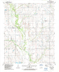
 1949 Nellie1953 Print · USGSThe Oklahoma plains around the Comanche and Stephens county lines come alive in this post-war survey. Researchers can trace the social fabric of rural life through numerous country schools and churches, including Starr Sch, Nellie, and the Rock Creek Cem.2 unique versions available
 - 1955 Map of Lawton, 1958 Print
 1955 Lawton1958 Print · USGSSouthwestern Oklahoma and North Texas are shown here in the mid-fifties, dominated by the Wichita Mountains and the vital Red River watershed. Genealogists and historians can trace the foundations of Lawton alongside rural landmarks like Rainy Mountain Church and Pleasant Hill School.5 unique versions available
 - 1956 Map of Letitia, 1959 Print
 1956 Letitia1959 Print · USGSSouthwestern Oklahoma's rural landscape is captured here in the mid-fifties at the junction of three counties. Genealogists and local historians can locate the Cem near Letitia, rural schoolhouses like Beaver Bend School, and the community hub at Pumpkin Center.2 unique versions available
 - 1956 Map of Nellie, 1960 Print
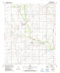
 1956 Nellie1960 Print · USGSComanche and Stephens counties are mapped in the mid-1950s, showing a rural landscape anchored by small agricultural and oil hubs. Genealogists can trace family footprints at Sterling Cemetery, Denton School, and the crossroads of Pumpkin Center.
 - 1957 Map of Hastings
 1957 Hastings1957 Print · USGSThe Red River frontier in the mid-fifties shows a landscape defined by the Chicago Rock Island and Pacific railroad and the booming oil industry. Genealogists and historians can trace family locations near Hastings, Byers, and the Petrolia Oil Field.2 unique versions available
 - 1957 Map of Burkburnett, 1958 Print
 1957 Burkburnett1958 Print · USGSThe Red River valley in the late fifties was a bustling corridor of oil production and rail transport. Genealogists and historians can trace the foundations of Burkburnett and Grandfield, finding old sites like Clara Ch and the Red River Oil Field.
 - 1957 Map of Randlett, 1958 Print
 1957 Randlett1958 Print · USGSThe Red River borderlands of Oklahoma and Texas come alive in this mid-century survey of the local oil fields and river bottoms. Researchers can trace rural lineages through sites like Randlett Cem, the Linville Sch (Aban'd), and the historical Perkins Reservation.2 unique versions available
 - 1962 Map of Chattanooga, 1964 Print
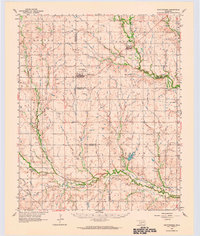 1962 Chattanooga1964 Print · USGSThe rural plains of Comanche and Tillman counties are captured here in the early 1960s. Genealogists and local historians can trace the foundations of Faxon and Chattanooga, along with landmarks like Ahpeatone Sch, Bible Ch, and the Chattanooga Cem.
 - 1962 Map of Walters, 1964 Print
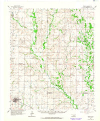
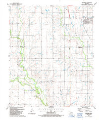
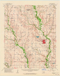 1962 Walters1964 Print · USGSCotton County during the early 1960s was a landscape defined by the oil industry and rural railroad life. Genealogy researchers can trace family landmarks like the New Salem Cem, Cookietown, and churches such as Brown Ch and Independent Ch.
 - 1962 Map of Temple, 1964 Print
 1962 Temple1964 Print · USGSThe cotton and oil country of southwestern Oklahoma comes to life here in the early sixties. Genealogists and historians can trace the foundations of Temple and Corum, locating family landmarks like Shakelford Cem and the Lone Star Ch.2 unique versions available
 - 1972 Map of Burkburnett, 1975 Print
 1972 Burkburnett1975 Print · USGSThe oil-rich plains of the Texas-Oklahoma border are captured here in the 1970s as the regional energy and military economy flourished. Researchers can trace the development of Burkburnett, locate old Oil Wells, and find landmarks like Hardin Sch or the Fish Hatchery.3 unique versions available
 - 1972 Map of Thornberry, 1975 Print
 1972 Thornberry1975 Print · USGSThe Texas-Oklahoma borderlands in the early 1970s reveal an landscape defined by heavy industry and military presence. Researchers can trace the extensive Texhoma Oil Field, locate the Cem at Thornberry, or study the boundaries of Perkins Reservation.
 - 1981 Map of Lawton
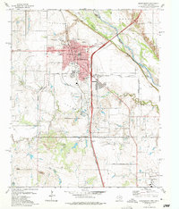
 1981 Lawton1981 Print · USGSSouthwestern Oklahoma in the early eighties shows a landscape shaped by military history and the rising peaks of the Wichitas. Researchers can trace the boundaries of the Fort Sill Military Reservation and locate early settlements like Meers, Chattanooga, and Richards Spur.
 - 1984 Map of Hooper, 1985 Print
 1984 Hooper1985 Print · USGSThe Oklahoma-Texas borderlands come to life in this mid-eighties survey of the river country south of Waurika. Genealogists and local historians can trace the rural landscape around Hooper and Hastings, including the Hastings Cemetery and Pleasant Ridge Community Ctr.
 - 1984 Map of Petrolia, 1985 Print
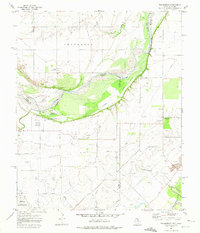
 1984 Petrolia1985 Print · USGSNorthern Texas at the dawn of the 1980s reveals a landscape defined by the winding Red River and the industrial footprint of the petroleum industry. Researchers can trace the Old Railroad Grade connecting Petrolia to Byers and locate the Riverside Cemetery near the river banks.
 - 1985 Map of Randlett
 1985 Randlett1985 Print · USGSRandlett and the surrounding Cotton County plains are captured here in the mid-1980s as the regional petroleum and ranching landscape matured. Genealogists and local historians can locate Randlett Cem, trace the Southwest Randlett Oil Field, and see the footprint of Big Pasture High Sch.
 - 1985 Map of Taylor
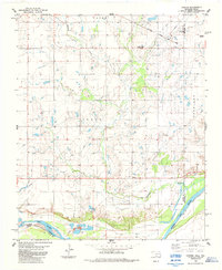
 1985 Taylor1985 Print · USGSThe Oklahoma-Texas borderlands along the Red River are captured here in the mid-eighties during a period of active oil exploration. Researchers can trace the petroleum infrastructure of the West Cache Creek Oil Field and locate the small settlement of Taylor.
 - 1985 Map of Devol
 1985 Devol1985 Print · USGSThe Oklahoma-Texas borderlands come into focus in the mid-1980s, centered on the railroad town of Devol. Researchers can trace the path of the Missouri Kansas Texas line or locate rural Oil Wells and the local Cem.
 - 1985 Map of Burkburnett, 1986 Print
 1985 Burkburnett1986 Print · USGSThe Red River valley and North Texas oil fields are captured here in the mid-eighties, showing the vital connection between military hubs and rail towns. Researchers can trace the path of the Missouri Kansas Texas railroad through Burkburnett or locate Waurika Lake and Sheppard Air Force Base.2 unique versions available
 - 1987 Map of Faxon
 1987 Faxon1987 Print · USGSSouthwestern Oklahoma near the Comanche and Cotton county line is captured in the late eighties as a quiet agricultural landscape. Genealogists can locate Faxon Cem and trace rural property lines near Faxon and the West Cache Creek drainage.
 - 1987 Map of Walters NE
 1987 Walters NE1987 Print · USGSCotton and Comanche Counties in the late 1980s reveal a landscape defined by petroleum extraction and creek-side settlements. Genealogists and historians can locate Allendale Cem, New Salem Ch, and the streets of Geronimo amidst a network of Oil Wells.
 - 1987 Map of Geronimo
 1987 Geronimo1987 Print · USGSGeronimo and the surrounding Comanche County townships are captured in the late 1980s as the regional rail and turnpike networks integrated with the rural landscape. Researchers can trace the path of the Oklahoma Kansas and Texas railroad and locate the Elm Grove Cem or the small settlement of Crosby.
 - 1987 Map of Whites Lake
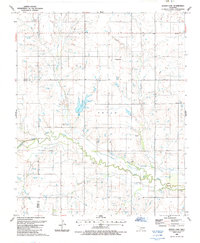 1987 Whites Lake1987 Print · USGSSouthern Oklahoma during the late 1980s reveals a rural landscape shaped by the winding course of Deep Red Creek. Local researchers can trace the vicinity of Ahpeatone Ch and identify water features like Whites Lake and the nearby Levee.
Showing maps 1-25 of 122
Top cities of Cotton County
Frequently asked questions
- What are the different types of historical maps available for Cotton County?
- What is the oldest map of Cotton County?
- Where can I purchase historical maps of Cotton County for my home or office?
- Where can I download high-res historical maps of Cotton County?
- Are there historical topographic maps available for Cotton County?
- Is there historical aerial imagery available for Cotton County?
- Where are historical maps of Cotton County sourced from?