1950s Maps of Cotton County, Oklahoma
Explore 6 historic maps of Cotton County from the 1950s. These maps offer a rare glimpse into what life looked like during the 1950s — showing old roads, neighborhoods, homes, and landmarks that have changed or disappeared over time.
Whether you're researching your family's past, planning a metal detecting trip, or studying how Cotton County's landscape evolved across the 1950s, these high-resolution maps are a powerful tool for exploring the history of this region.
- Focus on a specific era: All maps on this page are from the 1950s, giving you a focused view of this time period.
- See what’s changed: Compare century-old streets, trails, and buildings to today's modern landscape using overlays and satellite layers.
- Research with precision: Use these maps for genealogy, historical research, land use analysis, or educational projects.
- View, download, or print: Maps are fully viewable online in high resolution, and can be downloaded or printed for your own records.
Start exploring Cotton County's history through authentic maps from the 1950s. This is your window into the past.
Cotton County, OK maps
(6)- 1955 Map of Lawton, 1958 Print
 1955 Lawton1958 Print · USGSSouthwestern Oklahoma and North Texas are shown here in the mid-fifties, dominated by the Wichita Mountains and the vital Red River watershed. Genealogists and historians can trace the foundations of Lawton alongside rural landmarks like Rainy Mountain Church and Pleasant Hill School.5 unique versions available
 - 1956 Map of Letitia, 1959 Print
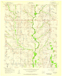 1956 Letitia1959 Print · USGSSouthwestern Oklahoma's rural landscape is captured here in the mid-fifties at the junction of three counties. Genealogists and local historians can locate the Cem near Letitia, rural schoolhouses like Beaver Bend School, and the community hub at Pumpkin Center.2 unique versions available
 - 1956 Map of Nellie, 1960 Print
 1956 Nellie1960 Print · USGSComanche and Stephens counties are mapped in the mid-1950s, showing a rural landscape anchored by small agricultural and oil hubs. Genealogists can trace family footprints at Sterling Cemetery, Denton School, and the crossroads of Pumpkin Center.
 - 1957 Map of Hastings
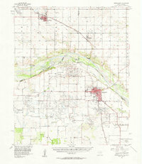
 1957 Hastings1957 Print · USGSThe Red River frontier in the mid-fifties shows a landscape defined by the Chicago Rock Island and Pacific railroad and the booming oil industry. Genealogists and historians can trace family locations near Hastings, Byers, and the Petrolia Oil Field.2 unique versions available
 - 1957 Map of Burkburnett, 1958 Print
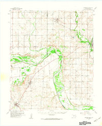
 1957 Burkburnett1958 Print · USGSThe Red River valley in the late fifties was a bustling corridor of oil production and rail transport. Genealogists and historians can trace the foundations of Burkburnett and Grandfield, finding old sites like Clara Ch and the Red River Oil Field.
 - 1957 Map of Randlett, 1958 Print
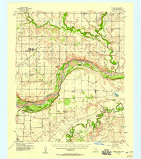 1957 Randlett1958 Print · USGSThe Red River borderlands of Oklahoma and Texas come alive in this mid-century survey of the local oil fields and river bottoms. Researchers can trace rural lineages through sites like Randlett Cem, the Linville Sch (Aban'd), and the historical Perkins Reservation.2 unique versions available
End of results
Showing maps 1-6 of 6
Top cities of Cotton County
Frequently asked questions
- What are the different types of historical maps available for Cotton County?
- What is the oldest map of Cotton County?
- Where can I purchase historical maps of Cotton County for my home or office?
- Where can I download high-res historical maps of Cotton County?
- Are there historical topographic maps available for Cotton County?
- Is there historical aerial imagery available for Cotton County?
- Where are historical maps of Cotton County sourced from?