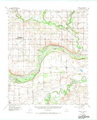
1957 Map of Randlett
USGS Topo · Published 1974About this map
The Red River and Wichita River converge across this landscape, defining the state boundary between Cotton County, Oklahoma, and Clay County, Texas. This mid-century survey illustrates a region shaped by petroleum extraction and agrarian life, where expansive drilling sites like the Cache Creek Oil Field and Thornberry Oil Field sit alongside established ranching and farming tracts. The settlement of Randlett serves as the primary hub in the north, while across the river in Texas, smaller communities such as Thornberry and Charlie are connected by rural routes like Robinson Road. Significant local landmarks include the Perkins Reservation (Boy Scout Camp) near McFarland Island, providing a glimpse into the social and civic geography of the era. The mapping of the Linville Sch (Aband) and the Randlett Cem offers specific points of interest for those tracing early twentieth-century rural development.
Find a feature on this map
41 named features on this map. Tap any name to fly to it.
Don’t see what you’re looking for? This feature index may not catch every label — zoom into the map to look around manually.
Map Details
Editions of this 1957 Randlett Map
2 editions found
Other maps of this area

1915 · Burkburnett
USGS Topo · 1:24,000

1918 · Buckburnett
USGS Topo · 1:31,680

1954 · Wichita Falls
USGS Topo · 1:250,000

1955 · Lawton
USGS Topo · 1:250,000

1956 · Henrietta
USGS Topo · 1:62,500

1957 · Hastings
USGS Topo · 1:62,500

1957 · Wichita Falls West
USGS Topo · 1:24,000

1957 · Burkburnett
USGS Topo · 1:62,500

1957 · Randlett
USGS Topo · 1:62,500

1957 · Wichita Falls East
USGS Topo · 1:62,500