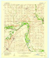
1957 Map of Hastings
USGS Topo · Published 1959About this map
The Red River serves as the primary boundary and geographical anchor for this mid-century survey, winding between Oklahoma and Texas. On the northern side, the town of Hastings sits near the tracks of the Chicago Rock Island and Pacific railroad, which parallels Beaver Creek as it heads toward Waurika. To the south, the landscape shifts toward the industrial activity of the Petrolia Oil Field and the small settlements of Byers and Petrolia.
Find a feature on this map
29 named features on this map. Tap any name to fly to it.
Don’t see what you’re looking for? This feature index may not catch every label — zoom into the map to look around manually.
Map Details
Editions of this 1957 Hastings Map
2 editions found
Other maps of this area

1901 · Addington
USGS Topo · 1:125,000

1905 · Montague
USGS Topo · 1:125,000

1954 · Sherman
USGS Topo · 1:250,000

1954 · Wichita Falls
USGS Topo · 1:250,000

1955 · Lawton
USGS Topo · 1:250,000

1956 · Henrietta
USGS Topo · 1:62,500

1957 · Hastings
USGS Topo · 1:62,500

1957 · Randlett
USGS Topo · 1:62,500

1957 · Wichita Falls East
USGS Topo · 1:62,500

1957 · Ardmore
USGS Topo · 1:250,000