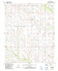
1987 Map of Ryan NE
USGS Topo · Published 1988About this map
Mud Creek and its many winding tributaries like Crooked Creek and Post Oak Creek dominate this rural landscape in Jefferson County. During the late 1980s, the small settlement of Claypool served as a local hub, anchored by the Community Ch near the eastern edge of the quadrangle. The map reveals a land defined by both natural watercourses and the industrial footprint of the local Oil Field, with numerous Oil Wells scattered across the township lines of Price and Grayson. A prominent Pipeline cuts across the southern terrain, illustrating the infrastructure required to support the region's energy production. The intricate drainage patterns of West Mud Creek provide a detailed look at the hydrology of the southern Oklahoma plains before more modern development further altered the surface features.
Find a feature on this map
13 named features on this map. Tap any name to fly to it.
Don’t see what you’re looking for? This feature index may not catch every label — zoom into the map to look around manually.
Map Details
Editions of this 1987 Ryan NE Map
This is the sole edition of this map. No revisions or reprints were ever made.
Other maps of this area

1901 · Addington
USGS Topo · 1:125,000

1957 · Ardmore
USGS Topo · 1:250,000

1962 · Ryan
USGS Topo · 1:62,500

1963 · Ardmore
USGS Topo · 1:250,000

1964 · Comanche SE
USGS Topo · 1:24,000

1964 · Comanche
USGS Topo · 1:24,000

1974 · Ringling NW
USGS Topo · 1:24,000

1974 · Loco
USGS Topo · 1:24,000
1974 · Grady
USGS Topo · 1:24,000
1986 · Ardmore
USGS Topo · 1:100,000