
1964 Map of Comanche
USGS Topo · Published 1965About this map
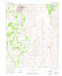
Comanche stands as the primary hub of this southern Oklahoma landscape during the mid-1960s, its street grid organized alongside the Chicago Rock Island and Pacific railroad. This survey provides a critical look at the region's historical boundaries, specifically marking the Old Oklahoma Territory Indian Territory Boundary Line which bisects the western portion of the map. The rural character of the area is defined by its water resources and industrial extraction, featuring Comanche Lake in the northeast and numerous oil wells and drill holes scattered across the terrain. Drainage is dominated by Cow Creek and Cottonwood Creek, which meander through a mix of wooded draws and open fields. Local social infrastructure is represented by the High Sch in town and the Countryside Ch to the east, while the local economy is further reflected in the presence of a Gravel Pit and wastewater management via the Sewage Disposal Ponds.
Find a feature on this map
19 named features on this map. Tap any name to fly to it.
Don’t see what you’re looking for? This feature index may not catch every label — zoom into the map to look around manually.
Map Details
Editions of this 1964 Comanche Map
2 editions found
Other maps of this area

1901 · Addington
USGS Topo · 1:125,000

1955 · Lawton
USGS Topo · 1:250,000

1957 · Hastings
USGS Topo · 1:62,500

1957 · Ardmore
USGS Topo · 1:250,000

1962 · Ryan
USGS Topo · 1:62,500

1962 · Temple
USGS Topo · 1:62,500

1963 · Ardmore
USGS Topo · 1:250,000

1963 · Harrisburg
USGS Topo · 1:24,000

1964 · Comanche SE
USGS Topo · 1:24,000

1964 · Duncan South
USGS Topo · 1:24,000