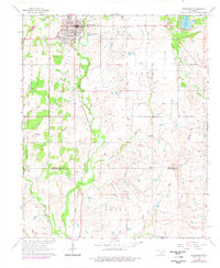
1964 Map of Comanche
USGS Topo · Published 1977About this map
The city of Comanche serves as the focal point of this mid-century landscape, positioned at the intersection of Highway 81 and Highway 53. The town's layout is clearly defined, featuring a High Sch and infrastructure like the Sewage Disposal ponds on the outskirts. The industrial and agricultural character of the region is evident through numerous Oil Wells scattered across the township of Brown and the surrounding area. The Chicago Rock Island and Pacific railroad runs north-south through the heart of the settlement, tracing a vital transportation corridor parallel to the highway.
Find a feature on this map
22 named features on this map. Tap any name to fly to it.
Don’t see what you’re looking for? This feature index may not catch every label — zoom into the map to look around manually.
Map Details
Editions of this 1964 Comanche Map
2 editions found

Other maps of this area

1901 · Addington
USGS Topo · 1:125,000

1955 · Lawton
USGS Topo · 1:250,000

1957 · Hastings
USGS Topo · 1:62,500

1957 · Ardmore
USGS Topo · 1:250,000

1962 · Ryan
USGS Topo · 1:62,500

1962 · Temple
USGS Topo · 1:62,500

1963 · Ardmore
USGS Topo · 1:250,000

1963 · Harrisburg
USGS Topo · 1:24,000

1964 · Comanche SE
USGS Topo · 1:24,000

1964 · Duncan South
USGS Topo · 1:24,000