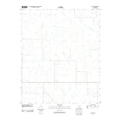
2010 Map of Ryan SE
USGS Topo · Published 2010About this map
West Mud Creek and Post Oak Creek carve through this section of Jefferson County, defining a landscape of drainage patterns and rural infrastructure in the early 21st century. The map reveals a strictly regulated grid of section roads, including N2940 Rd and E2000 Rd, which provide access to the various farmsteads and agricultural plots scattered throughout the territory. Notable named thoroughfares such as Ernest Dickey Blvd and Browns Chapel Rd suggest localized landmarks or historic family ties to the land. The intricate network of Red Creek tributaries illustrates the natural hydrological system that continues to shape the agricultural viability and settlement patterns of this Oklahoma region.
Find a feature on this map
19 named features on this map. Tap any name to fly to it.
Don’t see what you’re looking for? This feature index may not catch every label — zoom into the map to look around manually.
Map Details
Editions of this 2010 Ryan SE Map
This is the sole edition of this map. No revisions or reprints were ever made.
Other maps of this area

1901 · Addington
USGS Topo · 1:125,000

1905 · Montague
USGS Topo · 1:125,000

1954 · Sherman
USGS Topo · 1:250,000

1957 · Ardmore
USGS Topo · 1:250,000

1958 · Sherman
USGS Topo · 1:250,000

1962 · Ryan
USGS Topo · 1:62,500

1963 · Ardmore
USGS Topo · 1:250,000
1968 · Terral
USGS Topo · 1:24,000

1968 · Fleetwood
USGS Topo · 1:24,000
1968 · Prairie Valley School
USGS Topo · 1:24,000