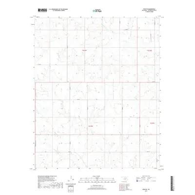
2018 Map of Ryan SE
USGS Topo · Published 2018About this map
Jefferson County's rural drainage patterns are defined by the winding paths of W Mud Cr and Red Cr, which cut through this section of southern Oklahoma. The landscape is organized by a strict sectional grid, where long-established local routes like Browns Chapel Rd and Ernest Dickey Blvd serve the agricultural community. In the eastern reaches, Post Oak Cr provides further definition to the terrain.
Find a feature on this map
25 named features on this map. Tap any name to fly to it.
Don’t see what you’re looking for? This feature index may not catch every label — zoom into the map to look around manually.
Map Details
Editions of this 2018 Ryan SE Map
This is the sole edition of this map. No revisions or reprints were ever made.
Other maps of this area

1901 · Addington
USGS Topo · 1:125,000

1905 · Montague
USGS Topo · 1:125,000

1954 · Sherman
USGS Topo · 1:250,000

1957 · Ardmore
USGS Topo · 1:250,000

1958 · Sherman
USGS Topo · 1:250,000

1962 · Ryan
USGS Topo · 1:62,500

1963 · Ardmore
USGS Topo · 1:250,000
1968 · Terral
USGS Topo · 1:24,000

1968 · Fleetwood
USGS Topo · 1:24,000
1968 · Prairie Valley School
USGS Topo · 1:24,000