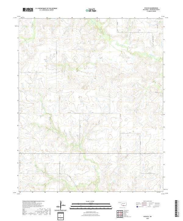
2022 Map of Ryan SE
USGS Topo · Published 2022About this map
W Mud Cr and Red Cr flow through this Jefferson County landscape, where the Jefferson County section line road system organizes the rural terrain into a clear grid of section boundaries. The map documents the persistent agricultural and ranching layout of the Red River valley region, showing the intersection of local routes like Browns Chapel Rd and the family-named Ernest Dickey Blvd. These roads follow the township and range lines of T5s R6w and T6s R5w, reflecting the long-standing Public Land Survey System that defined Oklahoma settlement. While modern in its production, the map preserves the exact names of minor drainage features like Post Oak Cr and the network of numbered section roads, such as NS 22 and Ew 15, which have served local families and travelers for generations.
Find a feature on this map
26 named features on this map. Tap any name to fly to it.
Don’t see what you’re looking for? This feature index may not catch every label — zoom into the map to look around manually.
Map Details
Editions of this 2022 Ryan SE Map
This is the sole edition of this map. No revisions or reprints were ever made.
Other maps of this area

1901 · Addington
USGS Topo · 1:125,000

1905 · Montague
USGS Topo · 1:125,000

1954 · Sherman
USGS Topo · 1:250,000

1957 · Ardmore
USGS Topo · 1:250,000

1958 · Sherman
USGS Topo · 1:250,000

1962 · Ryan
USGS Topo · 1:62,500

1963 · Ardmore
USGS Topo · 1:250,000
1968 · Terral
USGS Topo · 1:24,000

1968 · Fleetwood
USGS Topo · 1:24,000
1968 · Prairie Valley School
USGS Topo · 1:24,000