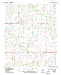
1987 Map of Ryan SE
USGS Topo · Published 1988About this map
West Mud Creek and its southern tributary Red Creek carve through this landscape in Jefferson County, where the topography transitions into the township divisions of Grayson, Blackburn, and Brown. The map documents a significant energy footprint in the late 1980s, particularly evident in the southeast where an extensive Oil Field is marked with numerous clustered wells. This concentration of resource extraction, alongside the presence of a Pipeline and scattered Oil Wells throughout the central terrain, illustrates the localized economic reliance on petroleum during this period. Beyond the industrial markers, the map preserves landmarks such as Post Oak Creek and the high point labeled Alone 912, providing a detailed look at the land's elevation and drainage patterns before further modern development.
Find a feature on this map
14 named features on this map. Tap any name to fly to it.
Don’t see what you’re looking for? This feature index may not catch every label — zoom into the map to look around manually.
Map Details
Editions of this 1987 Ryan SE Map
This is the sole edition of this map. No revisions or reprints were ever made.
Other maps of this area

1901 · Addington
USGS Topo · 1:125,000

1905 · Montague
USGS Topo · 1:125,000

1954 · Sherman
USGS Topo · 1:250,000

1957 · Ardmore
USGS Topo · 1:250,000

1958 · Sherman
USGS Topo · 1:250,000

1962 · Ryan
USGS Topo · 1:62,500

1963 · Ardmore
USGS Topo · 1:250,000
1968 · Terral
USGS Topo · 1:24,000

1968 · Fleetwood
USGS Topo · 1:24,000
1968 · Prairie Valley School
USGS Topo · 1:24,000