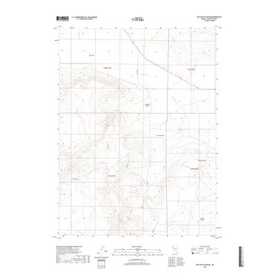
2018 Map of Rye Patch Canyon
USGS Topo · Published 2018About this map
Duck Flat dominates the northern landscape of this Washoe County region, where the high desert terrain transitions into a series of deeply etched drainages. The area is defined by its seasonal water patterns, most notably Duck Flat Wash which winds through the northern sections, and the vital Willow Springs situated near the head of Cedar Canyon. This 2018 survey reveals a sparse network of backroads, including Buckhorn Rd and Rd 26006, which provide the only access through this complex topography. The map illustrates a rugged geography of named breaks and draws, such as Rye Patch Canyon, Smokey Canyon, and Chicken Canyon, showing how the land has been shaped by intermittent flows and erosional forces in this remote part of Nevada.
Find a feature on this map
14 named features on this map. Tap any name to fly to it.
Don’t see what you’re looking for? This feature index may not catch every label — zoom into the map to look around manually.
Map Details
Editions of this 2018 Rye Patch Canyon Map
This is the sole edition of this map. No revisions or reprints were ever made.
Other maps of this area

1886 · Granite Range
USGS Topo · 1:250,000

1889 · Long Valley
USGS Topo · 1:250,000

1894 · Granite Range
USGS Topo · 1:250,000

1954 · Vya
USGS Topo · 1:250,000

1955 · Lovelock
USGS Topo · 1:250,000

1958 · Vya
USGS Topo · 1:250,000

1959 · Lovelock
USGS Topo · 1:250,000

1962 · Vya
USGS Topo · 1:250,000
1979 · Duck Lake
USGS Topo · 1:24,000
1980 · Burnt Lake
USGS Topo · 1:24,000