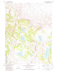
1980 Map of Burnt Lake
USGS Topo · Published 1980About this map
The high desert landscape of the Nevada-California border is defined by a series of shallow basins and ephemeral water sources in this 1980 survey. Situated on the western edge of Duck Flat, the terrain is marked by seasonal bodies of water such as Burnt Lake and Willow Lake, alongside several springs that served as critical watering points in an otherwise arid environment. The presence of Lackerman Airstrip indicates the reliance on aerial access in this sparsely populated region, while the Buckhorn Road provides the primary overland route through the sagebrush-covered hills. This area near the Lassen and Washoe County line reveals a network of canyons, including Express Canyon and Worland Canyon, which channel what little moisture reaches the playa floors. Notable landmarks like Pilgrim Spring and Sob Lake reflect the vernacular naming conventions of early ranchers and travelers navigating the transition from the high plateau down toward the basin floors.
Find a feature on this map
19 named features on this map. Tap any name to fly to it.
Don’t see what you’re looking for? This feature index may not catch every label — zoom into the map to look around manually.
Map Details
Editions of this 1980 Burnt Lake Map
2 editions found
Other maps of this area

1886 · Alturas
USGS Topo · 1:250,000

1886 · Honey Lake
USGS Topo · 1:250,000

1886 · Granite Range
USGS Topo · 1:250,000

1889 · Long Valley
USGS Topo · 1:250,000

1891 · Honey Lake
USGS Topo · 1:250,000

1892 · Alturas
USGS Topo · 1:250,000

1893 · Honey Lake
USGS Topo · 1:250,000

1894 · Granite Range
USGS Topo · 1:250,000

1954 · Observation Peak
USGS Topo · 1:62,500

1954 · Vya
USGS Topo · 1:250,000