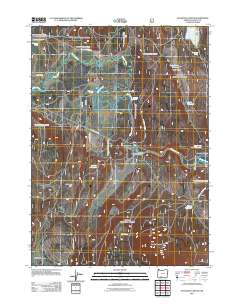
2011 Map of S'Ocholis Canyon
USGS Topo · Published 2011About this map
The Sprague River meanders through the heart of this Klamath County landscape, defining a region where water management and ranching are central to the local geography. Significant ranching operations like the McCready Ranch and Wolff Ranch occupy the lowlands, while a complex network of reservoirs—including Long Prairie Reservoir, Harris Reservoir, and Lone Pine Reservoir—points to the critical role of irrigation and water storage in this high-altitude basin.
Find a feature on this map
28 named features on this map. Tap any name to fly to it.
Don’t see what you’re looking for? This feature index may not catch every label — zoom into the map to look around manually.
Map Details
Editions of this 2011 S'Ocholis Canyon Map
This is the sole edition of this map. No revisions or reprints were ever made.
Other maps of this area

1889 · Klamath
USGS Topo · 1:250,000

1894 · Klamath
USGS Topo · 1:250,000

1955 · Klamath Falls
USGS Topo · 1:250,000

1956 · Calimus Butte
USGS Topo · 1:62,500

1957 · Chiloquin
USGS Topo · 1:62,500

1957 · Swan Lake
USGS Topo · 1:62,500

1957 · Modoc Point
USGS Topo · 1:62,500

1958 · Klamath Falls
USGS Topo · 1:250,000

1980 · Williamson River
USGS Topo · 1:100,000
1985 · Modoc Point
USGS Topo · 1:24,000