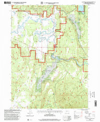
1998 Map of S'Ocholis Canyon
USGS Topo · Published 2000About this map
S'Ocholis Canyon and the winding Sprague River dominate this portion of the Winema National Forest during the late 1990s. The landscape is a study in resource management and high-desert hydrology, marked by numerous small-scale water developments like Mahogany Ridge Reservoir, Nut Reservoir, and Long Prairie Reservoir. These water sources, along with Whitehorse Spring and Kamkaun Spring, support the isolated cattle operations at Mc Cready Ranch and Wolff Ranch.
Find a feature on this map
30 named features on this map. Tap any name to fly to it.
Don’t see what you’re looking for? This feature index may not catch every label — zoom into the map to look around manually.
Map Details
Editions of this 1998 S'Ocholis Canyon Map
This is the sole edition of this map. No revisions or reprints were ever made.
Other maps of this area

1889 · Klamath
USGS Topo · 1:250,000

1894 · Klamath
USGS Topo · 1:250,000

1955 · Klamath Falls
USGS Topo · 1:250,000

1956 · Calimus Butte
USGS Topo · 1:62,500

1957 · Chiloquin
USGS Topo · 1:62,500

1957 · Swan Lake
USGS Topo · 1:62,500

1957 · Modoc Point
USGS Topo · 1:62,500

1958 · Klamath Falls
USGS Topo · 1:250,000

1980 · Williamson River
USGS Topo · 1:100,000
1985 · Modoc Point
USGS Topo · 1:24,000