
1994 Map of Sacramento
USGS Topo · Published 1994About this map
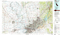
Sacramento and its sprawling suburban corridors anchor this mid-1990s landscape, illustrating the intense management of the Central Valley water system. The map highlights the critical engineering of the Yolo Bypass, the Sutter Bypass, and the Cache Creek Settling Basin, designed to protect the capital city from the floodwaters of the Sacramento River and Feather River. Military and aviation footprints are prominent at McClellan Air Force Base and Mather Air Force Base, while the growing residential reaches of Citrus Heights, Folsom, and Orangevale push toward the foothills near the Folsom Lake State Recreation Area. To the west, the rural character remains centered on agricultural outposts like Zamora and Nicolaus, and the unique campus of D-Q University, showing the region's diverse mix of urban development, defense installations, and deep-rooted irrigation-dependent farming.
Find a feature on this map
152 named features on this map. Tap any name to fly to it.
Don’t see what you’re looking for? This feature index may not catch every label — zoom into the map to look around manually.
Map Details
Editions of this 1994 Sacramento Map
2 editions found
Other maps of this area

1888 · Marysville
USGS Topo · 1:125,000

1888 · Smartsville
USGS Topo · 1:125,000

1889 · Jackson
USGS Topo · 1:125,000

1891 · Sacramento
USGS Topo · 1:125,000

1891 · Colfax
USGS Topo · 1:125,000

1891 · Marysville
USGS Topo · 1:125,000

1891 · Smartsville
USGS Topo · 1:125,000

1891 · Placerville
USGS Topo · 1:125,000

1892 · Jackson
USGS Topo · 1:125,000

1892 · Sacramento
USGS Topo · 1:125,000