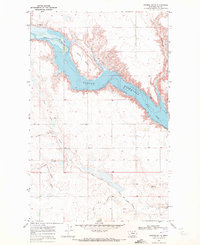
1969 Map of Saddle Butte
USGS Topo · Published 1972About this map
Fresno Reservoir dominates this Hill County landscape, where the impounded waters of the Milk River fill a winding valley framed by steep coulees. The terrain is defined by dramatic elevation shifts, particularly around Saddle Butte, which rises as a prominent landmark above the reservoir's northern banks. This 1969 field-checked survey by the U. S. Geological Survey shows a largely rural and hydraulic environment, with underwater contours provided by the U. S. Bureau of Reclamation.
Find a feature on this map
13 named features on this map. Tap any name to fly to it.
Don’t see what you’re looking for? This feature index may not catch every label — zoom into the map to look around manually.
Map Details
Editions of this 1969 Saddle Butte Map
This is the sole edition of this map. No revisions or reprints were ever made.
Other maps of this area

1904 · Assinniboine
USGS Topo · 1:62,500

1906 · Kremlin
USGS Topo · 1:62,500

1912 · Thibedeau Lake
USGS Topo · 1:125,000

1920 · Gildford
USGS Topo · 1:125,000

1943 · Gildford
USGS Topo · 1:125,000

1953 · Havre
USGS Topo · 1:250,000

1954 · Shelby
USGS Topo · 1:250,000

1957 · Havre
USGS Topo · 1:250,000

1958 · Shelby
USGS Topo · 1:250,000

1958 · Havre
USGS Topo · 1:250,000