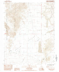
1984 Map of Saddle Peak Hills
USGS Topo · Published 1985About this map
Saratoga Springs and the drainage of the Amargosa River define this arid landscape within the southern reaches of Death Valley National Monument. The 1980s terrain is characterized by massive sand deposits, including the Ibex Dunes to the west and the concentrated Dumont Dunes and Little Dumont Dunes to the east. These shifting sands are bounded by the weathered Saddle Peak Hills and the Sperry Hills.
Find a feature on this map
20 named features on this map. Tap any name to fly to it.
Don’t see what you’re looking for? This feature index may not catch every label — zoom into the map to look around manually.
Map Details
Editions of this 1984 Saddle Peak Hills Map
This is the sole edition of this map. No revisions or reprints were ever made.
Other maps of this area

1933 · Avawatz Mountains
USGS Topo · 1:250,000

1947 · Trona
USGS Topo · 1:250,000

1948 · Trona
USGS Topo · 1:250,000

1948 · Avawatz Pass
USGS Topo · 1:62,500

1950 · Tecopa
USGS Topo · 1:62,500

1951 · Avawatz Pass
USGS Topo · 1:62,500

1951 · Tecopa
USGS Topo · 1:62,500

1951 · Shoshone
USGS Topo · 1:62,500

1953 · Trona
USGS Topo · 1:250,000

1956 · Silurian Hills
USGS Topo · 1:62,500