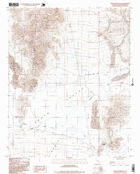
1996 Map of Saddle Peak Hills
USGS Topo · Published 1999About this map
Saratoga Springs and a series of vital desert water sources define this late-twentieth-century landscape where the Death Valley basin meets the Silurian Valley. The map documents a critical hydrologic corridor featuring the Amargosa River and Salt Creek, alongside named points like Amargosa Spring and Sheep Creek Spring. A single Prospect near the western edge serves as a reminder of the region's mineral exploration history. The terrain is dominated by significant sand formations, including the Ibex Dunes, Dumont Dunes, and Little Dumont Dunes, which are accessible via the unpaved Dumont Dunes Road. This survey captures the eastern boundary of Death Valley National Park as it was established during the 1990s, illustrating the complex topography of the Saddle Peak Hills and Sperry Hills.
Find a feature on this map
19 named features on this map. Tap any name to fly to it.
Don’t see what you’re looking for? This feature index may not catch every label — zoom into the map to look around manually.
Map Details
Editions of this 1996 Saddle Peak Hills Map
This is the sole edition of this map. No revisions or reprints were ever made.
Other maps of this area

1933 · Avawatz Mountains
USGS Topo · 1:250,000

1947 · Trona
USGS Topo · 1:250,000

1948 · Trona
USGS Topo · 1:250,000

1948 · Avawatz Pass
USGS Topo · 1:62,500

1950 · Tecopa
USGS Topo · 1:62,500

1951 · Avawatz Pass
USGS Topo · 1:62,500

1951 · Tecopa
USGS Topo · 1:62,500

1951 · Shoshone
USGS Topo · 1:62,500

1953 · Trona
USGS Topo · 1:250,000

1956 · Silurian Hills
USGS Topo · 1:62,500